15 Mountains in 2015 - #2: Beinn Capuill
My second mountain in 2015 was much smaller than the first. About half the size really. And it certainly doesn't feature on Munro's list of mountains over 3000 feet, not even on Corbett's list of mountains over 2500 feet or Graham's list of mountains over 2000 feet. But if there was a list of Scottish mountains over 1500 feet, then somewhere near the end of that list would be Beinn Capuill.
Its not a well trodden path. Indeed, for much of the route that I chose there wasn't any path. And such paths as there were were hardly in good condition.
Anyway, here it is:
Thursday 19th February, Beinn Capuill.
The skyline above the small Argyll town of Tighnabruaich is dominated by a small hill, known locally as 'The Duin' ("doo-in"). Behind this, a bit higher up, are some very minor crags, marked on the OS map as 'Cnoc an Fhithich' which completely hide the 'peak' of Beinn Capuill from view from the town.
I've climbed Beinn Capuill, or something that sounds like "Ben Ach Apple" when the locals name it, before, about 14 or 15 years ago. That day was grey and windy and the ground was very, very boggy. That time, I took the obvious path, starting from the Duin. This time I decided to try a different route, and began by following the 'public right of way' marked as 'path to new road' from just above the boat yard at Rubha Ban. Clearly, not many people use this path. Here's some pics of the bridges on it:

and

and

Yes, not only was the third bridge almost completely ruined, it was also almost completely overgrown and also crossed into the middle of a muddy thicket that took quite a while to escape from! But eventually I made it up to the A8003 (the 'new road'; well, it was new in the 1960s) and up a few steps to the signposted viewpoint (looking SSW towards Ardlamont point):

And here's a panorama taking in all of Bute:

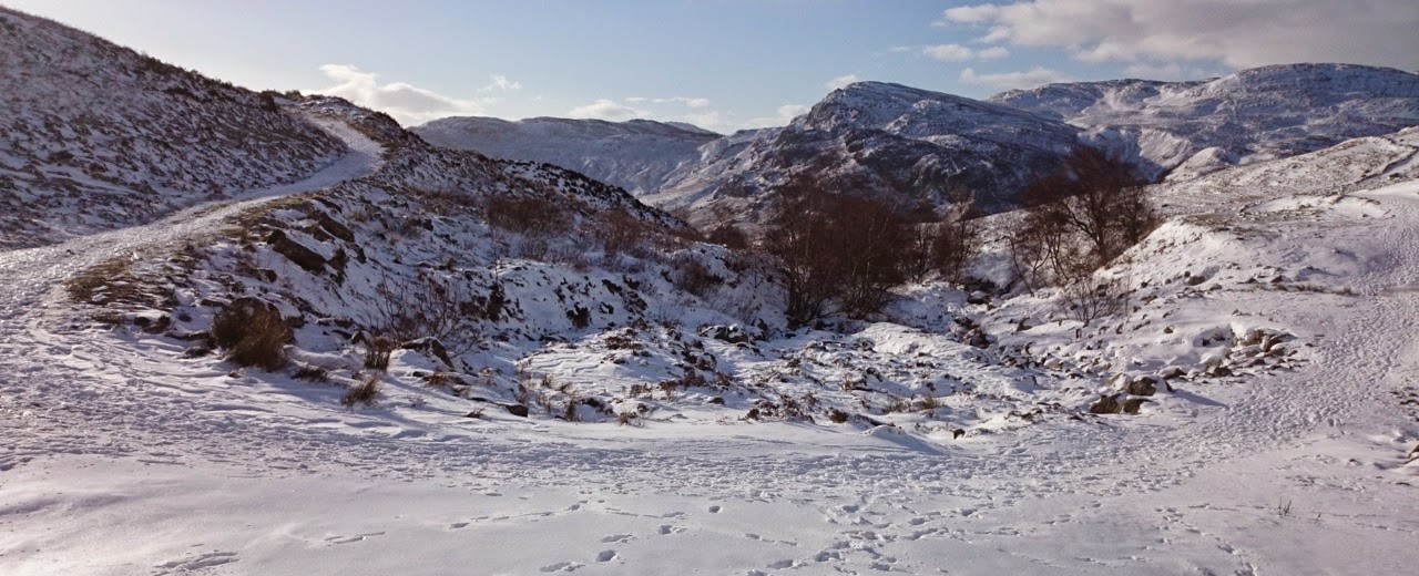
Here the path stopped. I crossed the rough ground above the viewpoint, climbed a deer fence, and scrambled up the hillside, to the top called Cnoc a' Chaisteil on the OS map. Then across a boggy, gnarly, bit of ground, across another deer fence (this one with a stile), and finally climbed up another rough slope to reach the plateau. Which looked a bit like this:

Finally, the top was in sight. But first there was an extremely boggy plateau to cross. There were occasional paths here, but none seemed to actually go anywhere useful, and all ended up in bogs, so there was nothing for it than to simply head across the ground in a vaguely straight line towards the top. Once across the plateau there was a steep, but much nicer, climb which zig-zagged between rock and small cliffs right to the top:

Success! Number 2 of 2015 in the bag. Here's the view from the top in three different directions:


Shortly after this it started sleeting, so I hastily made my way back down, this time following the direct 'path' to Tighnabruaich. At this point I saw a pretty big stag, but it had cleared off long before I got my camera out to take a pic. I also saw the remains of two sheep, both of which appeared to have taken unlucky tumbles off some small crags.
Looking back on the way down, Beinn Capuill looked more like a mountain than it had at any point on the way up:

And here's the view from Cnoc an Fhithich towards the Duin and Tighnabruaich:

Here's the map of the route, red on the way up, blue on the way back down:

I'm not sure I'd go as far as recommending this walk to anyone. It is probably the boggiest walk I've ever done. But I enjoyed it nevertheless. Think I'll aim for something higher for my 3rd mountain of 2015.
Labels: 15 Mountains in 2015, Scotland